Proposta para Definição do Perímetro Urbano de Porto Velho/RO - 2006
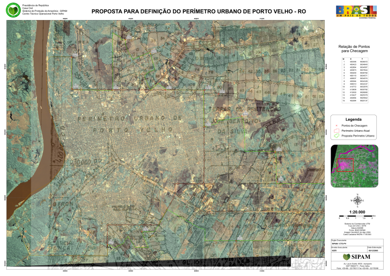
Carta imagem do Município de Porto Velho, Estado de Rondônia, elaborada com imagem Quickbird ano 2004 e Carta Cadastral fornecida pelo INCRA.
Citation proposal
(2006) . Proposta para Definição do Perímetro Urbano de Porto Velho/RO - 2006. https://panorama.sipam.gov.br/geonetwork/srv/api/records/0e6e8be1-b5ba-4d71-b660-334bc4b1e8c3
- Identification
- Distribution
- Quality
- Spatial rep.
- Ref. system
- Content
- Portrayal
- Metadata
- Md. constraints
- Md. maintenance
- Schema info
Identification
Data identification
Citation
- Date ( Publication )
- 2006-11-28T00:00:00
- Presentation form
- Digital map
- Presentation form
- Hardcopy map
- Status
- Completed
Originator
Avenida Lauro Sodré, 6500 - Aeroporto
Porto Velho
Rondônia
76803-260
Brasil
- Maintenance and update frequency
- As needed
- Keywords ( Theme )
-
-
Perímetro Urbano
-
Delimitação
-
Quickbird
-
Prefeitura Municipal de Porto Velho
-
- Keywords ( Place )
-
-
Rondônia
-
Legal constraints
- Access constraints
- Other restrictions
- Use constraints
- Other restrictions
- Other constraints
-
É vedado o uso comercial, ilícito ou danoso.
- Spatial representation type
- Vector
- Denominator
- 20000
- Metadata language
-
por
- Character set
- UTF8
- Topic category
-
- Geoscientific information
- Environment
- Imagery base maps earth cover
- Planning cadastre
))
Distribution
Digital transfer options
- OnLine resource
-
prefeiturapvh_Mapa%20Geral%20Logistica.pdf
(
WWW:DOWNLOAD-1.0-http--download
)Carta imagem do Município de Porto Velho/RO. Arquivo .pdf.
- OnLine resource
-
prefeiturapvh_Mapa%20Geral%20Logistica2.pdf
(
WWW:DOWNLOAD-1.0-http--download
)Carta imagem do Município de Porto Velho/RO. Arquivo .pdf.
Quality
Data quality
- Hierarchy level
- Dataset
- Statement
-
Carta imagem elaborada com imagem do satélite Quickbird ano 2004 e Carta Cadastral fornecida pelo Instituto Nacional de Colonização e Reforma Agrária - INCRA na escala 1:100.000.
Ref. system
- Reference system identifier
-
Projeção Universal Transversal de Mercator; Datum SAD69
Metadata
Metadata
- File identifier
- 0e6e8be1-b5ba-4d71-b660-334bc4b1e8c3 XML
- Metadata language
-
por
- Character set
- UTF8
- Date stamp
- 2025-04-02T14:26:10
- Metadata standard name
-
ISO 19115:2003/19139
- Metadata standard version
-
1.0
Author
Sistema de Proteção da Amazônia - SIPAM
-Luis Fernando Bueno
(Analista Gerencial
)Avenida Lauro Sodré, 6500 - Aeroporto
Porto Velho
Rondônia
76803-260
Brasil
Overviews
Provided by
