CARTA-IMAGEM DE RADAR DE ÁREA DE INTERESSE NO ESTADO DO PARÁ (TROMBETAS)
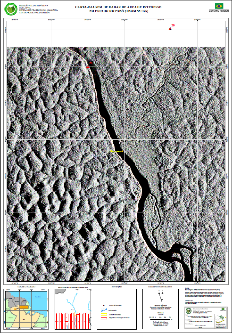
CARTA-IMAGEM DE RADAR DE ÁREA DE INTERESSE NO ESTADO DO PARÁ (TROMBETAS) ELABORADA A PATIR DE IMAGEM DE RADAR DE ABERTURA SINTÉTICA OBTIDA EM 12 DE SETEMBRO DE 2007, elaborada a partir de Base cartográfica do SIPAM/IBGE em escala original 1:250.000 (2004).
Imagem de Radar de Abertura Sintética obtida em 12 de setembro de 2007 pelo sensor SAR a bordo de aeronave R99 durante a Missão Oeste do Pará (segmento 63) com 6 metros de resolução espacial em composição colorida R(banda L polarização HH) G(banda L polarização HV) e B(banda L polarização VV). Com informações de Segmento de imagem de radar, Hidrografia, Limite Municipal e Ponto de interesse.
Citation proposal
. CARTA-IMAGEM DE RADAR DE ÁREA DE INTERESSE NO ESTADO DO PARÁ (TROMBETAS). https://panorama.sipam.gov.br/geonetwork/srv/api/records/1e5786b3-ee14-4f6c-9323-9589eca790c2
INSPIRE
Identification
- File identifier
- 1e5786b3-ee14-4f6c-9323-9589eca790c2 XML
Online resource
- Protocol
-
WWW:DOWNLOAD-1.0-http--download
Resource identifier
- Metadata language
-
por
- Spatial representation type
- Grid
Encoding
Projection
- code
-
WGS 84
Classification of data and services
- Topic category
-
- Boundaries
- Imagery base maps earth cover
Classification of data and services
Coupled resource
Coupled resource
Classification of data and services
Coupled resource
Coupled resource
Keywords
Other keywords
- Keywords
-
-
Carta Imagem
-
Geographic coverage
))
Temporal reference
Temporal extent
Temporal extent
- Date ( criation )
- 2009-03-24T15:57:00
Quality and validity
- Lineage
-
FONTE: Base cartográfica do SIPAM/IBGE em escala original 1:250.000 (2004). Imagem de Radar de Abertura Sintética obtida em 12 de setembro de 2007 pelo sensor SAR a bordo de aeronave R99 durante a Missão Oeste do Pará (segmento 63) com 6 metros de resolução espacial em composição colorida R(banda L
polarização HH) G(banda L polarização HV) e B(banda L polarização VV).
OBSERVAÇÃO: Como é possível observar no mapa de localização, o segmento não recobre toda a área de interesse.
Conformity
Conformity
Conformity
Conformity
Conformity
Conformity
Restrictions on access and use
Restrictions on access and use
Responsible organization (s)
Contact for the resource
- Organisation name
-
Sistema de Proteção da Amazônia - Centro Regional de Belém - Divisão de Sistematização de Informações
Responsible organization (s)
Contact for the resource
- Organisation name
-
Sistema de Proteção da Amazônia - Centro Regional de Belém - Divisão de Sistematização de Informações
Metadata information
Contact for the metadata
- Organisation name
-
Sistema de Proteção da Amazônia - Centro Regional de Belém - Divisão de Sistematização de Informações
- Date stamp
- 2025-04-02T14:21:03
- Metadata language
-
por
- Character set
- UTF8
SDS
Conformance class 1: invocable
Access Point URL
Endpoint URL
Technical specification
Conformance class 2: interoperable
Coordinate reference system
Quality of Service
Access constraints
Limitation
Use constraints
Limitation
Responsible custodian
Contact for the resource
Conformance class 3: harmonized
Overviews
Provided by
