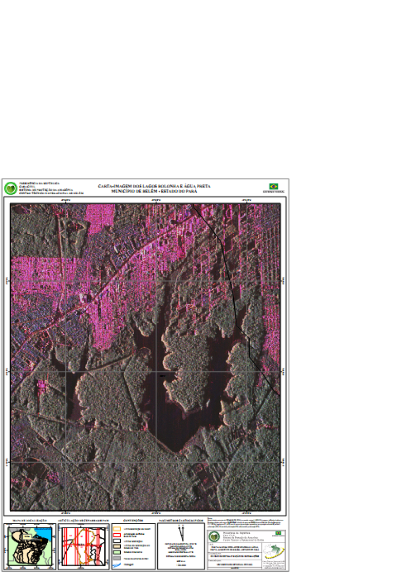
CARTA-IMAGEM DOS LAGOS BOLONHA E ÁGUA PRETA - MUNICÍPIO DE BELÉM - ESTADO DO PARÁ
CARTA-IMAGEM DOS LAGOS BOLONHA E ÁGUA PRETA - MUNICÍPIO DE BELÉM - ESTADO DO PARÁ, elaborada a partir Base de dados vetoriais do SIPAM/IBGE (2004) em escala original 1:250.000, imagens de Radar de Abertura Sintética obtidas pelo sensor SAR/SIPAM a bordo de aeronave R99B durante a Missão Ilha de Marajó de01/11/2006, (segmentos 31 e 32) com 6 metros de resolução espacial em composição colorida R(banda Lpolarização HH) G(banda L polarização HV) e B(banda L polarização VV). Com informações de Drenagem, Limites Municipais, Limites dos Municípios do Estado do Pará, Estados Brasileiros, Paises da América do Sul, Articulação de CenasSAR/SIPAM e Limite Municipal de Belém.
Citation proposal
. CARTA-IMAGEM DOS LAGOS BOLONHA E ÁGUA PRETA - MUNICÍPIO DE BELÉM - ESTADO DO PARÁ. https://panorama.sipam.gov.br/geonetwork/srv/api/records/2225a8ce-41fb-4978-97f8-a65892b1f3b2
INSPIRE
Identification
- File identifier
- 2225a8ce-41fb-4978-97f8-a65892b1f3b2 XML
Online resource
- Protocol
-
WWW:DOWNLOAD-1.0-http--download
Resource identifier
- Metadata language
-
por
- Spatial representation type
- Vector
Encoding
Projection
- code
-
WGS 84
Classification of data and services
- Topic category
-
- Imagery base maps earth cover
- Inland waters
Classification of data and services
Coupled resource
Coupled resource
Classification of data and services
Coupled resource
Coupled resource
Keywords
Other keywords
- Keywords ( Theme )
-
-
Carta Imagem
-
Geographic coverage
))
Temporal reference
Temporal extent
Temporal extent
- Date ( criation )
- 2008-04-19T11:14:00
Quality and validity
- Lineage
-
Base de dados vetoriais do SIPAM/IBGE (2004) em escala original 1:250.000, imagens de Radar de Abertura Sintética obtidas pelo sensor SAR/SIPAM a bordo de aeronave R99B durante a Missão Ilha de Marajó de01/11/2006, (segmentos 31 e 32) com 6 metros de resolução espacial em composição colorida R(banda Lpolarização HH) G(banda L polarização HV) e B(banda L polarização VV).
- Denominator
- 20000
Conformity
Conformity
Conformity
Conformity
Conformity
Conformity
Restrictions on access and use
Restrictions on access and use
Responsible organization (s)
Contact for the resource
- Organisation name
-
Sistema de Proteção da Amazônia - Centro Regional de Belém - Divisão de Sistematização de Informações
Responsible organization (s)
Contact for the resource
- Organisation name
-
Sistema de Proteção da Amazônia - Centro Regional de Belém - Divisão de Sistematização de Informações
Metadata information
Contact for the metadata
- Organisation name
-
Sistema de Proteção da Amazônia - Centro Regional de Belém - Divisão de Sistematização de Informações
- Date stamp
- 2025-04-02T14:19:11
- Metadata language
-
por
- Character set
- UTF8
SDS
Conformance class 1: invocable
Access Point URL
Endpoint URL
Technical specification
Conformance class 2: interoperable
Coordinate reference system
Quality of Service
Access constraints
Limitation
Use constraints
Limitation
Responsible custodian
Contact for the resource
Conformance class 3: harmonized
Overviews
Provided by
