Cobertura Vegetal e Mapa Planialtimétrico na Fazenda Zé Mineiro, Pará
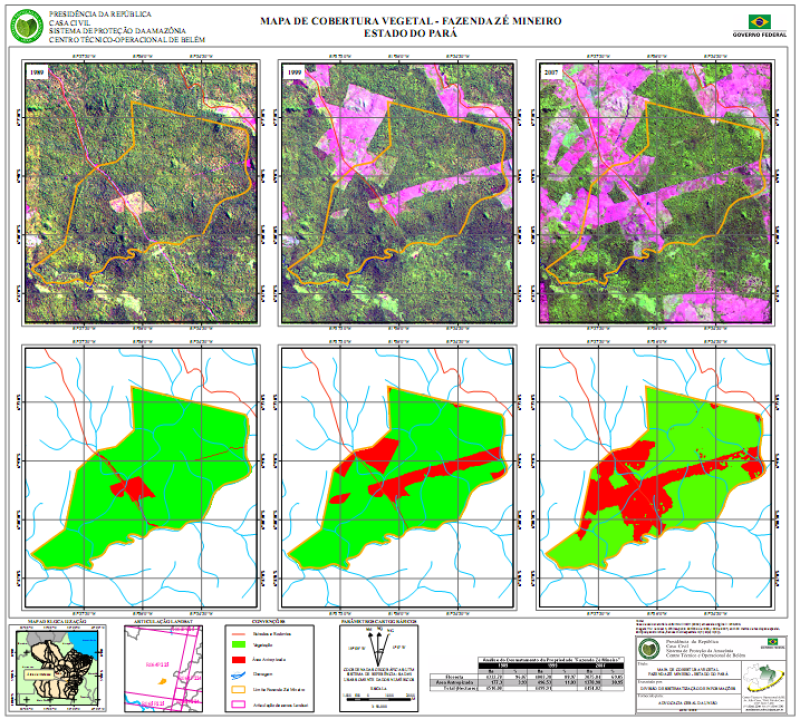
1. Mapa multitemporal em escala 1:90.000, mostrando a variação da cobertura vegetal na área da Fazenda Zé Mineiro, localizada no município de São Féliz do Xingu, Pará. O mapa foi elaborado a partir de imagens Landsat TM dos anos 1989, 1999 e 2007.
2. Mapa planialtimétrico da Fazenda Zé Mineiro, em escala 1:100.000, elaborado com a base vetorial do SIPAM/IBGE (2004).
Citation proposal
. Cobertura Vegetal e Mapa Planialtimétrico na Fazenda Zé Mineiro, Pará. https://panorama.sipam.gov.br/geonetwork/srv/api/records/40a02ce3-1d81-4349-9f00-ed34255313e9
- Identification
- Distribution
- Quality
- Spatial rep.
- Ref. system
- Content
- Portrayal
- Metadata
- Md. constraints
- Md. maintenance
- Schema info
Identification
Data identification
Citation
- Date ( criation )
- 2008-05-26T15:18:00
- Presentation form
- Digital map
- Status
- Completed
Distributor
Avenida Júlio César, 7060 - Val-de-cans
Belém
Pará
66.617-420
Brasil
- Maintenance and update frequency
- As needed
- Keywords
-
-
Cobertura Vegetal
-
Resource constraints
Legal constraints
- Access constraints
- semRestricoes
- Use constraints
- semRestricoes
- Classification
- Unclassified
- Denominator
- 90000
- Metadata language
-
por
- Character set
- UTF8
))
Distribution
Digital transfer options
- OnLine resource
-
Imagem1_s.png
(
WWW:DOWNLOAD-1.0-http--download
)
- OnLine resource
-
Imagem1.png
(
WWW:DOWNLOAD-1.0-http--download
)
- OnLine resource
-
ze_mineiro_classific.pdf
(
WWW:DOWNLOAD-1.0-http--download
)Cobertura Vegetal (Formato PDF- Tamanho 1.88MB)
Quality
Data quality
- Hierarchy level
- Dataset
- Statement
-
1. Mapa da cobertura vegetal obtido a partir de classificação não supervisionada de imagem Landsat TM com as bandas 1, 2, 3, 4, 5 e 7.
2. Mapa planialtimétrico elaborado com as informações vetoriais do SIPAM/IBGE e pontos dos limites da propriedade, fornecidos pela Advcacia Geral da União.
Spatial rep.
Vector spatial representation
- Topology level
- grafoCompletoDeSuperficie
- Geometric object type
- Complex
Georeferenceable
- Controlpoint Availability
- No
- Orientation parameter availability
- No
Georectified
- Checkpoint Availability
- No
- Point in Pixel
-
Ref. system
- Reference system identifier
-
WGS84
Metadata
Metadata
- File identifier
- 40a02ce3-1d81-4349-9f00-ed34255313e9 XML
- Metadata language
-
por
- Character set
- UTF8
- Date stamp
- 2025-04-02T14:37:22
- Metadata standard name
-
Perfil de Metadados Geospaciais do Brasil
- Metadata standard version
-
Novembro/2009
Author
Sistema de Proteção da Amazônia - Centro Regional de Belém - Divisão de Sistematização de Informações
-Aderson Araujo Avelar
(Analista de Suporte
)Avenida Júlio César, 7060 - Val-de-cans
Belém
Pará
66.617-420
Brasil
Md. constraints
Metadata constraints
Legal constraints
- Access constraints
- semRestricoes
- Use constraints
- semRestricoes
- Classification
- Unclassified
Overviews

Provided by
