CARTA IMAGEM - VSAT CRPV 2017
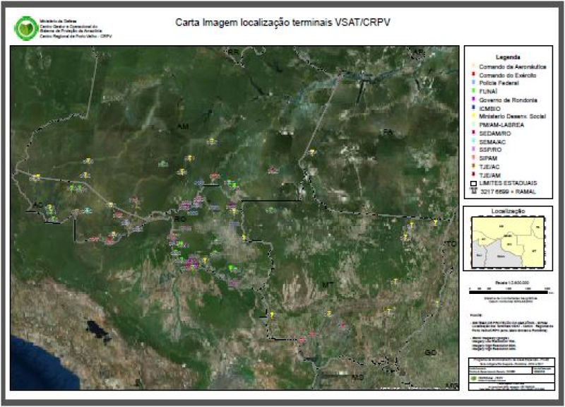
Carta Imagem, contendo OS TERMINAIS REMOTOS (VSATS), localizada na abrangência do estado de Rondônia (Acre, Mato Grosso e Rondônia). Elaborada na escala 1:2.800.000 sobre imagem do Google Maps.
Pontos dos terminais extraido do PIN (CENSIPAM).
Informações detalhadas no (BOX) INFORMAÇÕES DE QUALIDADE DOS DADOS.
Citation proposal
Sistema de Proteção da Amazônia - Centro Regional de Porto Velho - Divisão de Sensoriamento Remoto (2018) . CARTA IMAGEM - VSAT CRPV 2017. https://panorama.sipam.gov.br/geonetwork/srv/api/records/4e2683ef-902d-478b-9f78-263056026539
- Identification
- Distribution
- Quality
- Spatial rep.
- Ref. system
- Content
- Portrayal
- Metadata
- Md. constraints
- Md. maintenance
- Schema info
Identification
Data identification
Citation
- Date ( Publication )
- 2018-06-05T12:15:00
- Presentation form
- Digital map
- Status
- Completed
Author
Avenida Lauro Sodré, 6500 - Aeroporto
Porto Velho
Rondônia
76807-260
Brasil
- Maintenance and update frequency
- Annually
- Keywords ( Theme )
-
-
VSAT
-
- Keywords ( Place )
-
-
Porto Velho
-
Resource constraints
Legal constraints
- Access constraints
- Other restrictions
- Use constraints
- Other restrictions
- Classification
- Unclassified
- Spatial representation type
- Vector
- Denominator
- 50000
- Metadata language
-
por
- Character set
- UTF8
- Topic category
-
- Imagery base maps earth cover
- Planning cadastre
Distribution
- OnLine resource
-
Terminais_Vsat_crpv_imp.zip
(
WWW:DOWNLOAD-1.0-http--download
)Carta Imagem Localização Terminais VSAT CRPV 2017 (Formato zip)
Quality
Data quality
- Hierarchy level
- Dataset
- Statement
-
Carta Imagem, contendo OS TERMINAIS REMOTOS (VSATS), localizada na abrangência do estado de Rondônia (Acre, Mato Grosso e Rondônia). Elaborada na escala 1:2.800.000 sobre imagem do Google Maps.
Pontos dos terminais extraido do PIN (CENSIPAM).
- SISTEMA DE PROTEÇÃO DA AMAZÔNIA - SIPAM.
Localização dos Terminais VSAT (PIN).
- FUNDAÇÃO INSTITUTO BRASILEIRO DE GEOGRAFIA E ESTATÍSTICA - IBGE.
Base Cartográfica Contínua do Brasil - 1:1.000.000, Ano: 2014
- World Imagaery (google)
Imagery Low Resolution 15m,
Imagery Low Resolution 60m,
Imagery Low Resolution 30m,
Spatial rep.
Vector spatial representation
- Geometric object type
- Surface
Ref. system
- Reference system identifier
-
SIRGAS 2000
Metadata
Metadata
- File identifier
- 4e2683ef-902d-478b-9f78-263056026539 XML
- Metadata language
-
por
- Character set
- UTF8
- Date stamp
- 2025-04-02T14:27:33
- Metadata standard name
-
Perfil de Metadados Geospaciais do Brasil
- Metadata standard version
-
Novembro/2009
Author
Sistema de Proteção da Amazônia - Centro Regional de Porto Velho - Divisão de Sensoriamento Remoto
-Clementina Brito da Silva
(Analista
)Avenida Lauro Sodré, 6500
Porto Velho
Rondônia
76803-260
Brasil
Md. constraints
Metadata constraints
Legal constraints
- Access constraints
- Other restrictions
- Use constraints
- Other restrictions
- Classification
- Unclassified
Overviews
Provided by
