MAPAS DIVERSOS EM ÁREA DE INTERESSE NO ESTADO DO AMAPÁ (AMAPARI)
Mapas de desflorestamento, geomorfologia, cobertura vegetal e carta-imagem SAR-SIPAM em área de interesse do Exército no Estado do Amapá (AMAPARI) com bases cartográficas em escala de 1:100.000.
Citation proposal
. MAPAS DIVERSOS EM ÁREA DE INTERESSE NO ESTADO DO AMAPÁ (AMAPARI). https://panorama.sipam.gov.br/geonetwork/srv/api/records/8d66cb82-6211-4172-bea8-38f88aa7ba63
INSPIRE
Identification
- File identifier
- 8d66cb82-6211-4172-bea8-38f88aa7ba63 XML
Online resource
- Protocol
-
WWW:DOWNLOAD-1.0-http--download
- Protocol
-
WWW:DOWNLOAD-1.0-http--download
- Protocol
-
WWW:DOWNLOAD-1.0-http--download
- Protocol
-
WWW:DOWNLOAD-1.0-http--download
Resource identifier
- Metadata language
-
por
- Spatial representation type
- Vector
Encoding
Projection
- code
-
WGS 1984
Classification of data and services
- Topic category
-
- Imagery base maps earth cover
Classification of data and services
Coupled resource
Coupled resource
Classification of data and services
Coupled resource
Coupled resource
Keywords
Other keywords
- Keywords ( Theme )
-
-
Carta Imagem
-
- Keywords ( Theme )
-
-
Vegetação
-
- Keywords ( Theme )
-
-
Desflorestamento
-
- Keywords ( Theme )
-
-
Geomofologia
-
- Keywords ( Theme )
-
-
Relevo
-
- Keywords ( Place )
-
-
Amapari
-
Geographic coverage
))
Temporal reference
Temporal extent
Temporal extent
- Date ( criation )
- 2009-04-15T16:32:00
Quality and validity
- Lineage
-
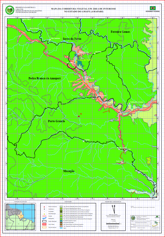
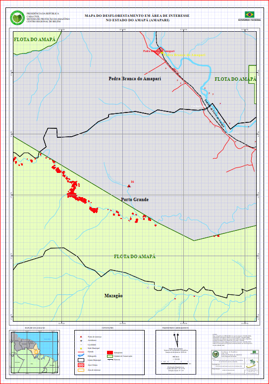
Delimitação municipal do IBGE em escala original 1:250.000 (2008). Delimitação de Unidades de Conservação Federais do MMA e IBAMA e Estaduais da SEMA/AP e SEMA/PA, em escala 1:100.000.Delimitação de Terras Indígenas da FUNAI em escala 1:100.000 (2007).Dados de antropismo do Programa de Monitoramento de Áreas Especiais - ProAE (SIPAM) 2007.
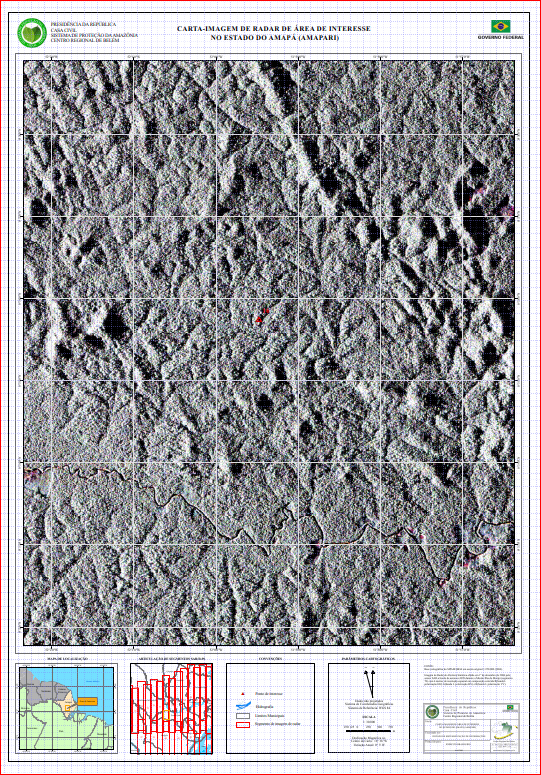
Imagem de Radar de Abertura Sintética obtida em 1º de dezembro de 2006 pelo sensor SAR a bordo de aeronave R99 durante a Missão Ilha do Marajó (segmento 78) com 6 metros de resolução espacial em composição colorida R(banda L polarização HH) G(banda L polarização HV) e B(banda L polarização VV).
- Denominator
- 100000
Conformity
Conformity
Conformity
Conformity
Conformity
Conformity
Restrictions on access and use
Restrictions on access and use
Responsible organization (s)
Contact for the resource
- Organisation name
-
Sistema de Proteção da Amazônia - Centro Regional de Belém - Divisão de Sistematização de Informações
Responsible organization (s)
Contact for the resource
- Organisation name
-
Sistema de Proteção da Amazônia - Centro Regional de Belém - Divisão de Sistematização de Informações
Metadata information
Contact for the metadata
- Organisation name
-
Sistema de Proteção da Amazônia - Centro Regional de Belém - Divisão de Sistematização de Informações
- Date stamp
- 2025-04-02T14:19:12
- Metadata language
-
por
- Character set
- UTF8
SDS
Conformance class 1: invocable
Access Point URL
Endpoint URL
Technical specification
Conformance class 2: interoperable
Coordinate reference system
Quality of Service
Access constraints
Limitation
Use constraints
Limitation
Responsible custodian
Contact for the resource
Conformance class 3: harmonized
Overviews
Provided by
