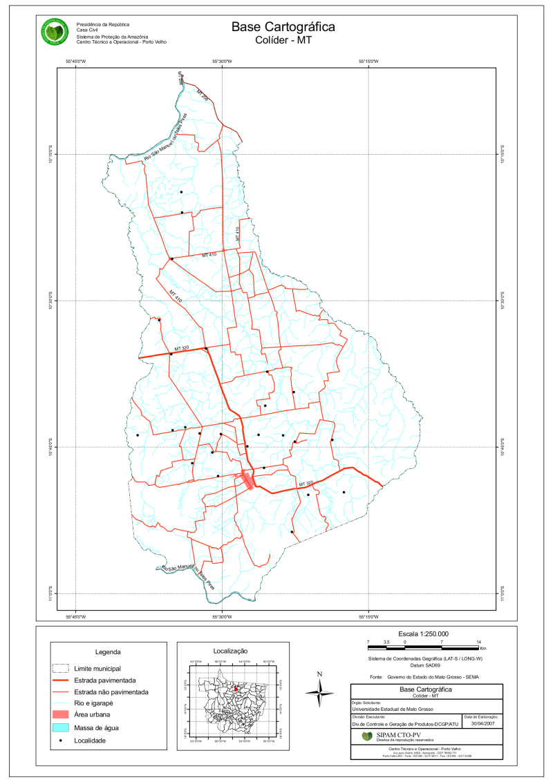
Base Cartográfica - Colider/MT
Mapa temático contendo a base cartográfica do Município de Colider, Estado de Mato Grosso, elaborado com dados vetoriais armazenados na base SIPAM.
Citation proposal
(2007) . Base Cartográfica - Colider/MT. https://panorama.sipam.gov.br/geonetwork/srv/api/records/9947a6be-ff81-4435-b847-0f39e45f496c
INSPIRE
Identification
- File identifier
- 9947a6be-ff81-4435-b847-0f39e45f496c XML
Online resource
- Protocol
-
WWW:DOWNLOAD-1.0-http--download
Resource identifier
- Metadata language
-
por
- Spatial representation type
- Grid
Encoding
Projection
- code
-
Sistema de Coordenadas Geográficas - Datum SAD69
Classification of data and services
- Topic category
-
- Geoscientific information
- Imagery base maps earth cover
Classification of data and services
Coupled resource
Coupled resource
Classification of data and services
Coupled resource
Coupled resource
Keywords
Other keywords
- Keywords ( Theme )
-
-
Base Cartográfica
-
Estrada
-
Hidrografia
-
Área Urbana
-
- Keywords ( Place )
-
-
Mato Grosso
-
Colíder
-
Geographic coverage
N
S
E
W
))
Temporal reference
Temporal extent
Temporal extent
- Date ( Publication )
- 2007-04-22T00:00:00
Quality and validity
- Lineage
-
Fonte dos dados vetoriais:
Governo do Estado do Mato Grosso - SEMA/MT
- Denominator
- 250000
Conformity
Conformity
Conformity
Conformity
Conformity
Conformity
Restrictions on access and use
- Access constraints
-
É vedadado o uso comercial, ilícito ou danoso.
Restrictions on access and use
Responsible organization (s)
Contact for the resource
- Organisation name
-
Sistema de Proteção da Amazônia/SIPAM
Responsible organization (s)
Contact for the resource
- Organisation name
-
Sistema de Proteção da Amazônia/SIPAM
Metadata information
Contact for the metadata
- Organisation name
-
Sistema de Proteção da Amazônia - SIPAM
- Date stamp
- 2020-04-30T17:09:06
- Metadata language
-
por
- Character set
- UTF8
SDS
Conformance class 1: invocable
Access Point URL
Endpoint URL
Technical specification
Conformance class 2: interoperable
Coordinate reference system
Quality of Service
Access constraints
Limitation
Use constraints
Limitation
Responsible custodian
Contact for the resource
Conformance class 3: harmonized
Overviews
base_cartografica_colider.png
Provided by

Views
Access to the portal
Read here the full details and access to the data.
Associated resources
Not available