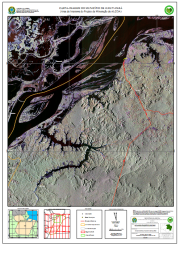
CARTA-IMAGEM DO MUNICÍPIO DE JURUTI-PARÁ(Área de Interesse do Projeto de Mineração da ALCOA)
CARTA-IMAGEM DO MUNICÍPIO DE JURUTI-PARÁ(Área de Interesse do Projeto de Mineração da ALCOA), elaborada a partir de Base de dados vetoriais do SIPAM/IBGE (2004) em escala original 1:250.000 e imagens de Radar de Abertura Sintética obtidas pelo sensor SAR/SIPAM a bordo de aeronave R99B durante a Missão Terra do Meio Oeste (segmentos 58 e 59) com 18 metros de resolução espacial em 10/04/2006 em composição colorida R(banda L polarização HH) G(banda L polarização HV) e G(banda L polarização VV). Com informações de Localidades, Estradas e Rodovias, Limite Municipal de Juruti, Segmento SAR, Limites Municipais, Sedes Municipais e Área de Estudo.
Citation proposal
. CARTA-IMAGEM DO MUNICÍPIO DE JURUTI-PARÁ(Área de Interesse do Projeto de Mineração da ALCOA). https://panorama.sipam.gov.br/geonetwork/srv/api/records/d2bdf404-ef5d-4630-8243-1b04a917e3f1
INSPIRE
Identification
- File identifier
- d2bdf404-ef5d-4630-8243-1b04a917e3f1 XML
Online resource
- Protocol
-
WWW:DOWNLOAD-1.0-http--download
- Protocol
-
WWW:DOWNLOAD-1.0-http--download
- Protocol
-
WWW:DOWNLOAD-1.0-http--download
Resource identifier
- Metadata language
-
por
- Spatial representation type
- Vector
Encoding
Projection
- code
-
WGS 84
Classification of data and services
Classification of data and services
Coupled resource
Coupled resource
Classification of data and services
Coupled resource
Coupled resource
Keywords
Other keywords
- Keywords
-
-
Carta Imagem
-
Geographic coverage
))
Temporal reference
Temporal extent
Temporal extent
- Date ( criation )
- 2008-06-10T10:14:00
Quality and validity
- Lineage
-
Base de dados vetoriais do SIPAM/IBGE (2004) em escala original 1:250.000 e imagens de Radar de Abertura Sintética obtidas pelo sensor SAR/SIPAM a bordo de aeronave R99B durante a Missão Terra do Meio Oeste (segmentos 58 e 59) com 18 metros de resolução espacial em 10/04/2006 em composição colorida R(banda L polarização HH) G(banda L polarização HV) e G(banda L polarização VV).
- Denominator
- 70000
Conformity
Conformity
Conformity
Conformity
Conformity
Conformity
Restrictions on access and use
Restrictions on access and use
Responsible organization (s)
Contact for the resource
- Organisation name
-
Sistema de Proteção da Amazônia - Centro Regional de Belém - Divisão de Sistematização de Informações
Responsible organization (s)
Contact for the resource
- Organisation name
-
Sistema de Proteção da Amazônia - Centro Regional de Belém - Divisão de Sistematização de Informações
Metadata information
Contact for the metadata
- Organisation name
-
Sistema de Proteção da Amazônia - Centro Regional de Belém - Divisão de Sistematização de Informações
- Date stamp
- 2020-04-06T11:27:53
- Metadata language
-
por
- Character set
- UTF8
SDS
Conformance class 1: invocable
Access Point URL
Endpoint URL
Technical specification
Conformance class 2: interoperable
Coordinate reference system
Quality of Service
Access constraints
Limitation
Use constraints
Limitation
Responsible custodian
Contact for the resource
Conformance class 3: harmonized
Overviews

Provided by
