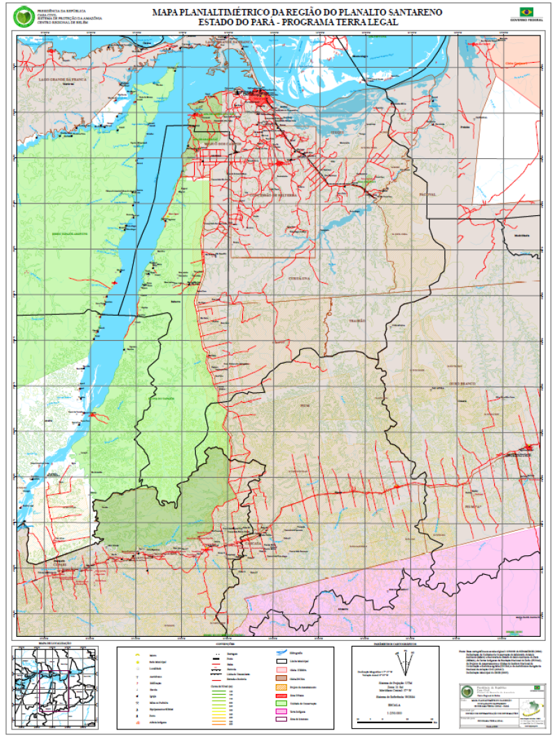
MAPA PLANIALTIMÉTRICO DA REGIÃO DO PLANALTO SANTARENO - ESTADO DO PARÁ - PROGRAMA TERRA LEGAL
MAPA PLANIALTIMÉTRICO DA REGIÃO DO PLANALTO SANTARENO - ESTADO DO PARÁ - PROGRAMA TERRA LEGAL, elaborado a partir de Base de Dados Vetoriais do SIPAM/IBGE em escala original 1:250.000 (2004). Com informações de Localidades, Sedes Municipais, Estradas e Rodovias, Hidrografia, Área Urbana, Limites Municipais, Áreas Especiais (Unidades de Conservação e Terras Indígenas), Limite de Gleba (ITERPA) e Gleba (INCRA), Projetos de Assentamentos e Curvas de Nível.
Citation proposal
. MAPA PLANIALTIMÉTRICO DA REGIÃO DO PLANALTO SANTARENO - ESTADO DO PARÁ - PROGRAMA TERRA LEGAL. https://panorama.sipam.gov.br/geonetwork/srv/api/records/fb3574cc-73b2-43ba-af81-026f20d697a3
INSPIRE
Identification
- File identifier
- fb3574cc-73b2-43ba-af81-026f20d697a3 XML
Online resource
- Protocol
-
WWW:DOWNLOAD-1.0-http--download
Resource identifier
- Metadata language
-
por
- Spatial representation type
- Vector
Encoding
Projection
- code
-
WGS 84
Classification of data and services
- Topic category
-
- Boundaries
- Imagery base maps earth cover
Classification of data and services
Coupled resource
Coupled resource
Classification of data and services
Coupled resource
Coupled resource
Keywords
Other keywords
- Keywords ( Theme )
-
-
Mapa Planimétrico
-
- Keywords ( Place )
-
-
Planalto Santareno
-
Geographic coverage
))
Temporal reference
Temporal extent
Temporal extent
- Date ( criation )
- 2009-10-20T00:00:00
Quality and validity
- Lineage
-
Base de Dados Vetoriais do SIPAM/IBGE em escala original 1:250.000 (2004).Delimitação de Unidades de Conservação do Ministério do Meio Ambiente (MMA) e Secretaria de Estado do Meio Ambiente do Pará (SEMA), de Terras Indígenas da Fundação Nacional do Índio (FUNAI), de Projetos de Assentamentos e Glebas do Instituto Nacional de Colonização e Reforma Agrária (INCRA) e de Aeródromos da Agência Nacional de Aviação Civil (ANAC). Delimitação Municipal do IBGE (2005).
- Denominator
- 250000
Conformity
Conformity
Conformity
Conformity
Conformity
Conformity
Restrictions on access and use
Restrictions on access and use
Responsible organization (s)
Contact for the resource
- Organisation name
-
Sistema de Proteção da Amazônia - Centro Regional de Belém - Divisão de Sistematização de Informações
Responsible organization (s)
Contact for the resource
- Organisation name
-
Sistema de Proteção da Amazônia - Centro Regional de Belém - Divisão de Sistematização de Informações
Metadata information
Contact for the metadata
- Organisation name
-
Sistema de Proteção da Amazônia - Centro Regional de Belém - Divisão de Sistematização de Informações
- Date stamp
- 2025-04-02T14:22:23
- Metadata language
-
por
- Character set
- UTF8
SDS
Conformance class 1: invocable
Access Point URL
Endpoint URL
Technical specification
Conformance class 2: interoperable
Coordinate reference system
Quality of Service
Access constraints
Limitation
Use constraints
Limitation
Responsible custodian
Contact for the resource
Conformance class 3: harmonized
Overviews
Provided by
