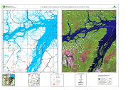
MAPA BASE E CARTA-IMAGEM DO MUNICÍPIO DE LIMOEIRO DO AJURU - ESTADO DO PARÁ
MAPA BASE E CARTA-IMAGEM DO MUNICÍPIO DE LIMOEIRO DO AJURU - ESTADO DO PARÁ, elaborada a partir de Base de Dados Vetoriais do SIPAM/IBGE (escala original 1:250.000)Imagens TM Landsat 5 órbita-ponto 224/061 24/08/2003 com 30 metros de resolução espacial. Composição colorida R(5) G(4) B(3). Com informações de Localidades, Sedes Municipais, Estradas e Rodovias, Drenagem, Limite Municipal deLimoeio do Ajuru, Limites Municipais e Áreas Urbanas.
Citation proposal
. MAPA BASE E CARTA-IMAGEM DO MUNICÍPIO DE LIMOEIRO DO AJURU - ESTADO DO PARÁ. https://panorama.sipam.gov.br/geonetwork/srv/api/records/07bc6de8-1b06-4285-8cfb-36ddfe00246d
- Identification
- Distribution
- Quality
- Spatial rep.
- Ref. system
- Content
- Portrayal
- Metadata
- Md. constraints
- Md. maintenance
- Schema info
Identification
Data identification
Citation
- Date ( criation )
- 2008-05-23T10:29:00
- Presentation form
- Digital map
- Status
- Completed
Distributor
Avenida Júlio César, 7060 - Val-de-cans
Belém
Pará
66.617-420
Brasil
- Maintenance and update frequency
- As needed
Resource constraints
Legal constraints
- Access constraints
- Other restrictions
- Use constraints
- Other restrictions
- Classification
- Unclassified
- Spatial representation type
- Vector
- Denominator
- 150000
- Metadata language
-
por
- Character set
- UTF8
))
Distribution
Digital transfer options
- OnLine resource
-
Limoeiro_Para.pdf
(
WWW:DOWNLOAD-1.0-http--download
)Carta Imagem (Formato PDF - Tamanho MB)
- OnLine resource
-
Limoeiro_Par._s.png
(
WWW:DOWNLOAD-1.0-http--download
)
Quality
Data quality
- Hierarchy level
- Dataset
- Statement
-
Base de Dados Vetoriais do SIPAM/IBGE (escala original 1:250.000)Imagens TM Landsat 5 órbita-ponto 224/061 24/08/2003 com 30 metros de resolução espacial. Composição colorida R(5) G(4) B(3).
Ref. system
- Reference system identifier
-
WGS 84
Metadata
Metadata
- File identifier
- 07bc6de8-1b06-4285-8cfb-36ddfe00246d XML
- Metadata language
-
por
- Character set
- UTF8
- Date stamp
- 2025-04-02T14:24:00
- Metadata standard name
-
Perfil de Metadados Geospaciais do Brasil
- Metadata standard version
-
Novembro/2009
Author
Sistema de Proteção da Amazônia - Centro Regional de Belém - Divisão de Sistematização de Informações
-Débora Emerique de Lima
(Estagiária
)Avenida Júlio César, 7060 - Val-de-cans
Belém
Pará
66.617-420
Brasil
Md. constraints
Metadata constraints
Legal constraints
- Access constraints
- Other restrictions
- Use constraints
- Other restrictions
- Classification
- Unclassified
Overviews
Provided by
