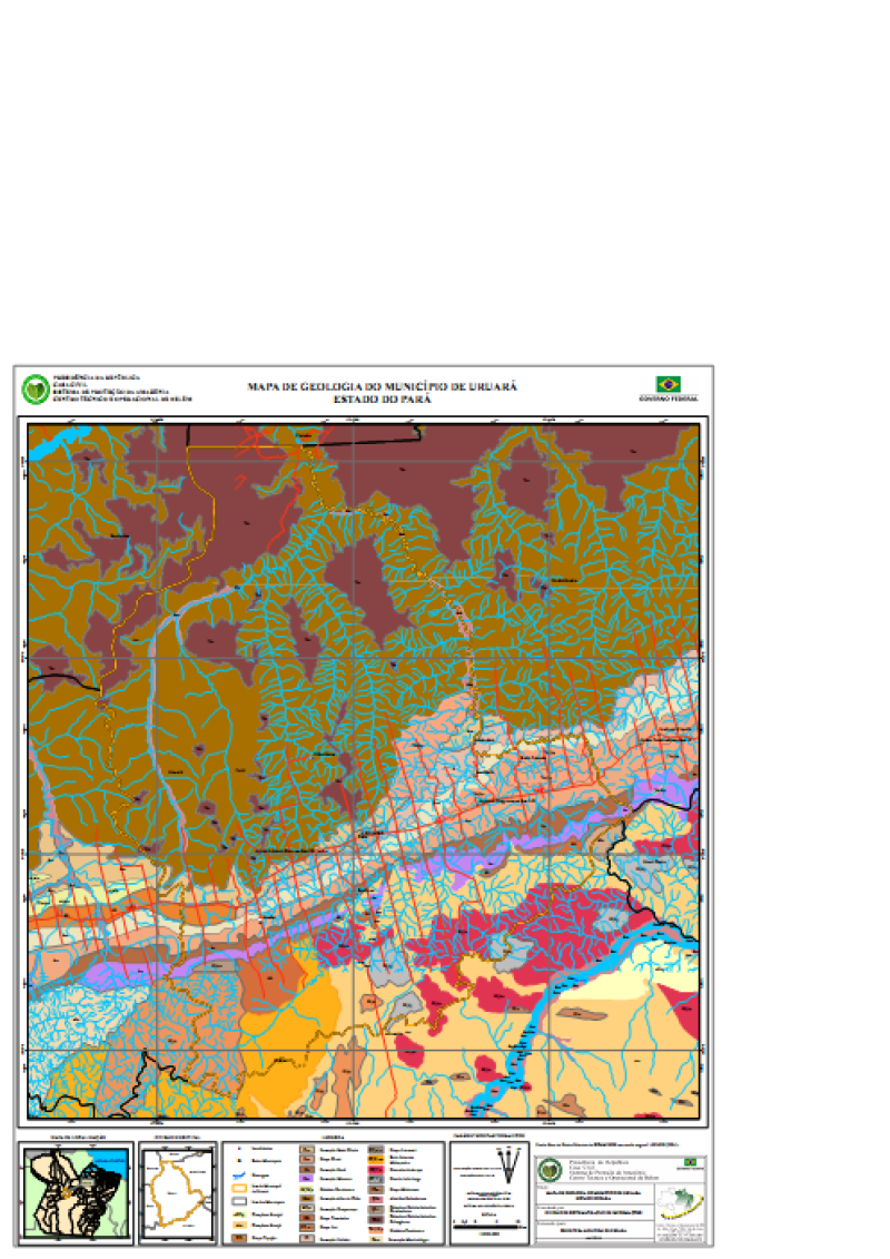
MAPA DE GEOLOGIA DO MUNICÍPIO DE URUARÁ ESTADO DO PARÁ
MAPA DE GEOLOGIA DO MUNICÍPIO DE URUARÁ ESTADO DO PARÁ, elaborada a partir Base de Dados Vetoriais do SIPAM/IBGE em escala original 1:250.000 (2004). Com informações de Localidades, Sedes Municipais, Drenagem, Limite Municipalde Uruará, Limites Municipais e geologia.
Citation proposal
. MAPA DE GEOLOGIA DO MUNICÍPIO DE URUARÁ ESTADO DO PARÁ. https://panorama.sipam.gov.br/geonetwork/srv/api/records/97b60cbb-0693-4819-92ad-e126fcb1a747
- Identification
- Distribution
- Quality
- Spatial rep.
- Ref. system
- Content
- Portrayal
- Metadata
- Md. constraints
- Md. maintenance
- Schema info
Identification
Data identification
Citation
- Date ( criation )
- 2008-04-16T11:32:00
- Presentation form
- Digital map
- Status
- Completed
Distributor
Avenida Júlio César, 7060 - Val-de-cans
Belém
Pará
66.617-420
Brasil
- Maintenance and update frequency
- As needed
- Keywords
-
-
Mapa Geológico
-
Resource constraints
Legal constraints
- Access constraints
- Other restrictions
- Use constraints
- Other restrictions
- Classification
- Unclassified
- Spatial representation type
- Vector
- Denominator
- 250000
- Metadata language
-
por
- Character set
- UTF8
- Topic category
-
- Imagery base maps earth cover
))
Distribution
- OnLine resource
-
uruara_geologia.pdf
(
WWW:DOWNLOAD-1.0-http--download
)Mapa Geológico (Formato PDF- Tamanho 1.80MB)
Quality
Data quality
- Hierarchy level
- Dataset
- Statement
-
de Dados Vetoriais do SIPAM/IBGE em escala original 1:250.000 (2004).
Ref. system
- Reference system identifier
-
WGS 84
Metadata
Metadata
- File identifier
- 97b60cbb-0693-4819-92ad-e126fcb1a747 XML
- Metadata language
-
por
- Character set
- UTF8
- Date stamp
- 2020-04-14T11:01:23
- Metadata standard name
-
Perfil de Metadados Geospaciais do Brasil
- Metadata standard version
-
Novembro/2009
Author
Sistema de Proteção da Amazônia - Centro Regional de Belém - Divisão de Sistematização de Informações
-Débora Emerique de Lima
(Estagiária
)Avenida Júlio César, 7060 - Val-de-cans
Belém
Pará
66.617-420
Brasil
Md. constraints
Metadata constraints
Legal constraints
- Access constraints
- Other restrictions
- Use constraints
- Other restrictions
- Classification
- Unclassified
Overviews
Provided by
